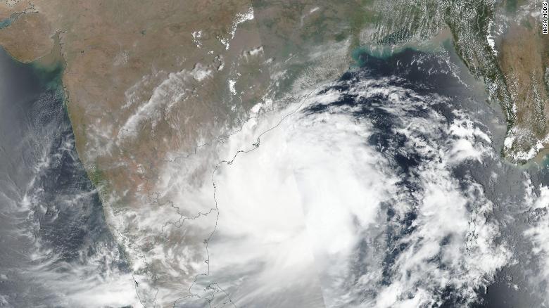
BY CNN New Delhi, India — What is expected to be India’s strongest landfalling tropical cyclone in nearly five years is barreling towards 100 million people on the east coast, causing officials to begin emergency evacuations.
On Thursday, Tropical Cyclone Fani had winds of 190 kmph (118 mph) with gusts of 201 kmph (124 mph), making it equivalent in intensity to a Category 3 major hurricane on the Saffir-Simpson scale. It is expected to hit Odisha state on Friday afternoon.
As Fani was classified as an “extremely severe cyclonic storm” in India, the country’s Coast Guard and Navy deployed ships and helicopters for relief and rescue operations. Army and Air Force units have also been put on standby in Odisha, West Bengal and Andhra Pradesh states.
Some 900 cyclone shelters have been set up across Odisha to house evacuees and school is canceled across the state on Thursday and Friday. Teams are going door to door to warn people.
“They are being told what to take with them if they leave and the precautions they need to take if they stay,” said Ameya Patnaik, assistant commandant for the National Disaster Response Force (NDRF) in Odisha.
Evacuations have also begun neighboring Andhra Pradesh, while those in West Begal have been told to be ready to leave, officials told CNN. Fishermen have been warned not to venture into the sea due to the extreme conditions.
Fani, which is still about 270 kilometers (170 miles) off of the coast off India, strengthened rapidly on Monday and Tuesday, becoming the strongest storm to move through the Bay of Bengal this early in the year since Tropical Cyclone Nargis in 2008.
Nargis went on to strike Myanmar with winds over 200 kph (124 mph), bringing a devastating storm surge and flooding rainfall that resulted in more than 100,000 deaths in the country.
- Chamisa under fire over US$120K donation
- Mavhunga puts DeMbare into Chibuku quarterfinals
- Pension funds bet on Cabora Bassa oilfields
- Councils defy govt fire tender directive
Keep Reading
Impacts
Fani is expected to bring large storm surges and significant wind damage near the landfall location. Inland flooding will also be a major threat.
Portions of eastern India and Bangladesh can expect 150 to 300 mm (6 to 12 inches) of rain with locally higher amounts regardless of the intensity.
As Fani approaches India it will be moving nearly parallel to the coast. A slight move to the east or west would have a significant impact on the timing of landfall as well as the intensity. A more easterly track means that landfall would be farther north in India, perhaps even into Bangladesh.
If that happens, the storm would likely be a category or two weaker as it moves over cooler waters.
Cyclone season
Fani is the first tropical cyclone of the year in the northern Indian Ocean.
The season doesn’t have a defined start and end like the Atlantic basin season, but it does have two main periods of activity: late April to early June, and October to November.
These two periods are prior to, and immediately following, India’s southwest monsoon season. The southwest monsoon season lasts from June through September and provides India with the vast majority of its annual rainfall.
Tropical cyclone activity during the monsoon season is extremely rare because the monsoon is characterized by high wind shear, which makes it difficult for tropical storms to form.